Today I’m very excited to be speaking with John Laxson who leads software engineering at Kespry.
Welcome to the studio, John.
Happy to be here.
To get started, could you tell me a bit about Kespry?
What we’ve done since the very early days at Kespry is focus on making drone technology as easily and quickly accessible to a wide variety of industries and applications. We’ve done that by eliminating all of the training and expertise needed, so that somebody who needs aerial data can go straight from a simple and easy to fly drone, to the data that they need to make decisions, without having to master all of the intervening technologies.
How does the Kespry Drone 2s system work? Are there joysticks or is it automated?
There are no joysticks. All you do is take the drone out, plug a battery in and using an iPad that we provide and the Kespry app, draw a circle around the area that you’re interested in with your finger. The drone automatically picks the most efficient flight path to fly. You just hit takeoff and off it goes. The drone automatically comes back and lands. The iPad copies all of the data from the drone. No SD cards or cables. You then connect to your wifi network at home or work and all of the data is quickly uploaded to the Kespry Cloud. Kespry then coordinates getting all the data stitched through a photogrammetry pipeline and delivered to you in the Kespry Cloud as the 2D and 3D products that you need.
For someone who’s very familiar with aggregates, construction, insurance or mining but maybe they’re not so familiar with drones – how easy would it be for them to learn the Kespry system?
We could teach it to them in 10 minutes.
In January of this year, Kespry announced Drone 2s which provides centimeter level accuracy of 2 to 10 centimeters. How is it able to achieve such incredible accuracy?
Well, there are two parts that go into this. One is that we use state of the art kinematics technology to get accurate positioning of the drone based on using a base station on the ground, as well as, a high-quality survey grade receiver on the drone to perform differential GPS. We integrated all of that, as well as, the corrections data, with our entire data delivery pipeline. Just as we made the drone as easy to fly as possible, we’ve taken all of the survey mastery out of delivering centimeter accuracy from the drone. By being able to control the entire stack and integrate all of the technologies, we’ve been able to squeeze every last bit of achievable accuracy out of the system that someone might have to take hours and days of their own time to master just once.
With the launch of Drone 2s, Kespry transitioned away from multiple ground control points and aerial flight targets – why was that?
We learned very early in Kespry’s lifetime that there was a need for high accuracy drone data to perform tasks like mine planning, earthworks, and survey. When we started out with ground control, we quickly learned that they were a huge pain. You had to place them, which could include driving around a hundred plus acre site. Then you’d need to do the actual RTK survey to get your centimeter accurate positions for each one. You’d then need to fly low, so that the drone could see the targets accurately, and then we’d have to do a bunch more work on the backend, which takes longer to correct all of the data based on the control points that were set out. That process was so tedious that we just said there has to be a better way. We then built the Drone 2s system which integrates post-processed kinematic technology to remove all of that painful process. Now it doesn’t take you any longer to fly a centimeter accurate mission than it does to fly a regular mission.
What is the difference between PPK and RTK? Why would someone need RTK compared to PPK?
The difference mainly depends on when we do the differential processing that gets you the centimeter accuracy. RTK stands for real time kinematics, which means that the GPS module on the drone or the rover is doing the corrections as it goes using a live stream of data from the base station. PPK stands for post-processed kinematics, where we record the raw data that both the base station, as well as, the drone experience. When the data is uploaded to Kespry Cloud, we perform the corrections there. Which helps to eliminate the need for things like a real-time link to get the data from the ground station to the drone. It also makes you more resilient because if there is interference, you won’t notice.
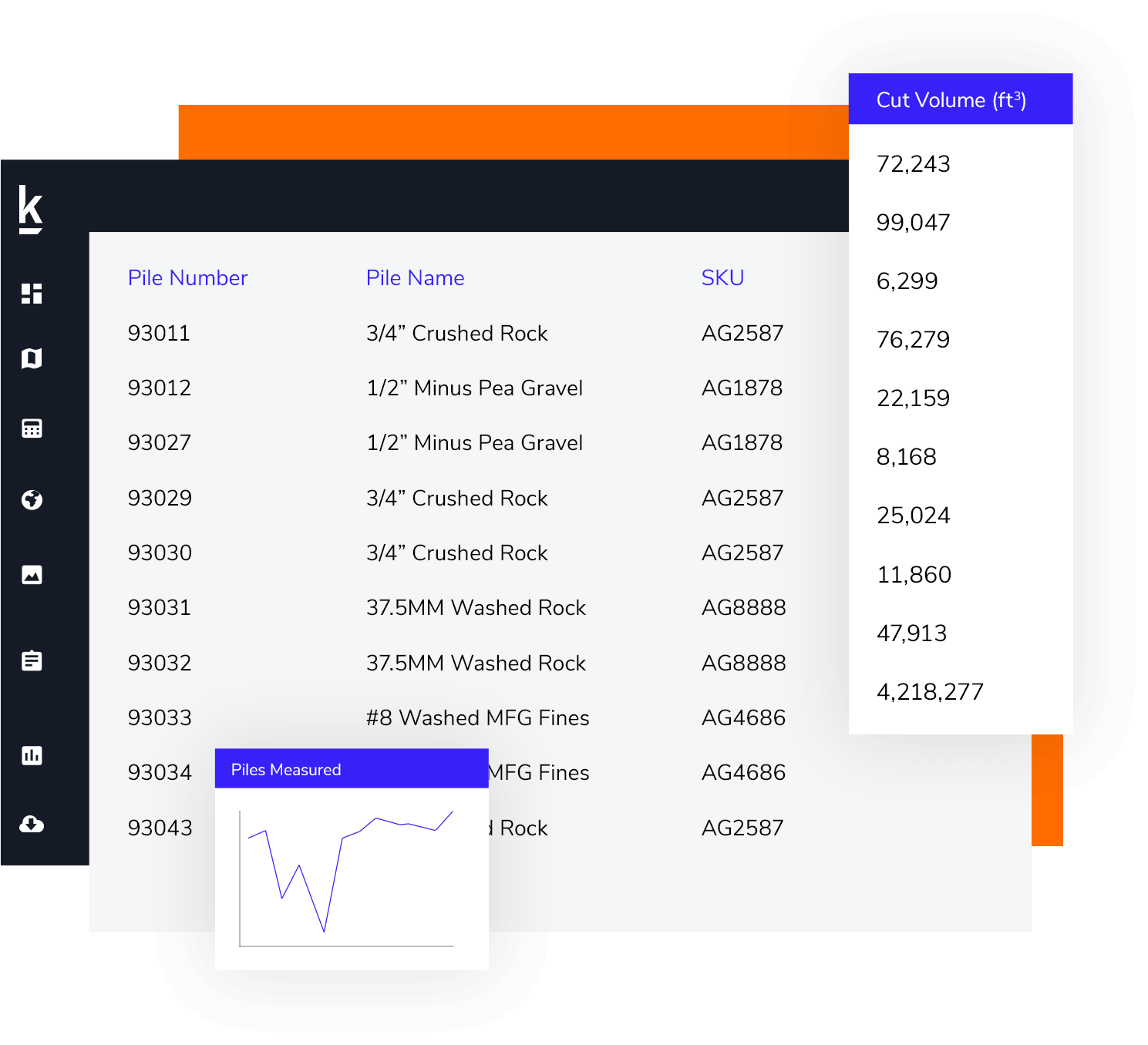
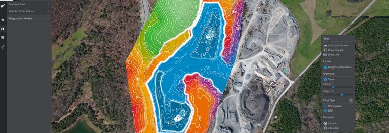
If I log into the online Kespry Cloud, what types of data can I see? Do I need to install any software on my computer?
Kespry Cloud is entirely browser based and can be accessed by just about any computer. When you log in, you’ll get easy access to all of your data which includes the raw photos that the drone took, as well as, 3D reconstructions, surface models, shapefiles, contours and the actual visual top-down imagery that we’ve put together from all of the individual frames.
How easy is it to navigate the Kespry Cloud? How is the data shared?
It’s very simple. As soon as you log in, you’ll be presented with all of your flights that you’ve done and they will all be displayed in a way that fits in your browser. Even though your Kespry drone may take two to ten gigabytes of imagery and we process that into much more, we convert it all so that you can get your high-resolution data without transferring all of it to your browser all at once.
How is the Kespry Cloud data exported? Is the data compatible with programs like AutoCAD?
You just click download and all of the data that we’ve used in delivering the Kespry Cloud experience can be exported to your computer, and then you can do anything. The sky’s the limit.
For folks in aggregates, construction, insurance or mining, who are currently researching which drone solution is the right one for them – what advice do you have for them?
The big thing to look at is how the drone experience is going to connect with your day-to-day workflow? How is it going to give you an easier day and not just one more thing to manage? This ease of use is what we’re really focused on at Kespry.
For businesses who are considering Kespry – why should they select Kespry instead of other drone companies?
Almost everybody who has looked at Kespry has not been a drone pilot. With Kespry, you’re not going to worry about joysticks. You’re not going to be wondering how to get the actual data. You’re not spending hours on training, and you always have the support of our Customer Success team. Just being able to fly and not worry about the wind or the weather or the health of the drone and being able to perform your mission safely. Being able to automatically upload data to the Kespry Cloud and having us focus on running hundreds of servers, to give you accurate data as fast as possible.
John, it has been so great to chat with you. Thank you so much for your time!
The pleasure was all mine.